


What Is Geolocation?
Geolocation refers to determining the physical location of a device or user in the real world. It's a process that can draw from many different data sources and methods, including:
- Satellite systems (GPS, GLONASS, Galileo, BeiDou)
- Wi-Fi and Bluetooth networks
- IP address lookups
- Cellular towers
- Internal device sensors (accelerometer, gyroscope, magnetometer)
Depending on which data source is used, the accuracy and purpose of the geolocation process can vary dramatically—from city-level precision in IP-based methods to centimeter-level accuracy with Ultra-Wideband (UWB).
If you're building a web or mobile app that needs location data, tools like AbstractAPI's IP Geolocation API
offer a simple and privacy-focused way to identify a user's approximate location via IP address—ideal for content personalization, fraud prevention, and regional access control.
Deep Dive into Satellite Navigation (GNSS)
When most people think of geolocation, they think of GPS. But GPS is just one of several satellite-based navigation systems that make up the Global Navigation Satellite System (GNSS). Let's unpack how these systems work under the hood.
1. The Three Segments of GPS
GPS consists of three interdependent segments:
- Space Segment: A constellation of roughly 30 satellites orbiting 20,000 km above Earth, each broadcasting a continuous signal with timing and orbit data.
- Control Segment: Ground stations that track satellites, synchronize atomic clocks, and ensure the system's overall accuracy.
- User Segment: The receivers in your phone, smartwatch, or car that process those satellite signals to calculate position.
Together, these components form one of the world's most reliable positioning systems, with accuracy typically within 5–10 meters.
2. How Trilateration Works
GPS positioning is based on trilateration, not triangulation.
Your receiver measures how long it takes for signals from at least four satellites to reach it. By multiplying that time delay by the speed of light, it calculates the distance to each satellite. The point where the resulting spheres intersect gives your precise position.
This process also accounts for time errors in your device's internal clock—one reason why four satellites (not three) are necessary.
Imagine bubbles expanding from each satellite; where they overlap, that's you 🌐.
3. Beyond GPS: The GNSS Family
GPS is part of a global ecosystem known as GNSS, which includes:
- GLONASS (Russia)
- Galileo (Europe)
- BeiDou (China)
- QZSS (Japan, regional)
Modern smartphones and IoT devices use multi-constellation GNSS, combining data from several systems to improve accuracy, reduce signal loss, and provide faster fixes—even in challenging environments.
Developers interested in integrating GNSS-derived coordinates with IP-based data can combine them using tools like AbstractAPI's Geolocation APIs to validate or enhance positional accuracy.
4. GPS Accuracy and Limitations
Despite its sophistication, GPS has natural limitations:
- Atmospheric Interference: Signal delay caused by ionospheric and tropospheric distortion.
- Multipath Effects: Reflections from buildings in urban areas (the "urban canyon" problem).
- Satellite Geometry: Poor satellite positioning reduces accuracy (measured by "DOP"—Dilution of Precision).
- Indoor Signal Loss: Signals struggle to penetrate roofs and thick walls.
That's why your map app often switches to Wi-Fi or cellular methods when you step indoors or enter a tunnel.
The Spectrum of Non-Satellite Geolocation
GPS isn't always reliable indoors or underground. That's where other geolocation technologies take over. Each one has unique trade-offs between speed, accuracy, and power consumption.
🖥️ IP Geolocation
IP Geolocation identifies location using a device's IP address and large geolocation databases. It's a server-side method—no GPS chips or sensors required.
- Accuracy: City or regional level (typically 10–50 km)
- Ideal For: Websites, APIs, and security tools
- Common Use Cases:
- Content localization (auto-setting language or currency)
- Fraud detection (matching IP vs billing address)
- Geofencing or compliance (e.g., GDPR region detection)
You can try it instantly with the AbstractAPI IP Geolocation API, which returns data like country, city, postal code, and even timezone from a simple IP request.
📡 Wi-Fi Positioning (WPS)
Wi-Fi Positioning works by analyzing nearby Wi-Fi access points and matching them to known coordinates in public databases.
- Accuracy: 10–50 meters
- Best For: Dense urban areas and indoor environments
- Example: Your phone can locate you in a café without GPS by recognizing the Wi-Fi network around you.
This is why Android and iOS recommend keeping Wi-Fi turned on for "improved location accuracy."
📱 Cellular Positioning
Cellular positioning estimates a device's location using the signal strength and timing from nearby cell towers.
- Accuracy: 100–1000 meters (depends on tower density)
- Best For: Low-power, fallback positioning
- Use Cases:
- E911 emergency services
- IoT tracking devices
- Fleet management in areas with weak GPS
📍 Micro-Location (BLE Beacons & UWB)
For indoor environments where precision matters, Bluetooth Low Energy (BLE) and Ultra-Wideband (UWB) take center stage.
- Accuracy: Up to 10 centimeters
- Best For: Enclosed environments
- Use Cases:
- In-store navigation and customer analytics
- Asset tracking in warehouses or hospitals
- Augmented reality (AR) positioning systems
This technology underpins smart retail and logistics—creating hyper-local, context-aware experiences.
⚖️ Choosing the Right Tool for the Job
Here's how all these technologies compare:
| Technology | Typical Accuracy | Power Consumption | Ideal Environment | Infrastructure Needs | Common Use Cases |
|---|---|---|---|---|---|
| GPS / GNSS | 5–10 meters | High | Outdoors | None | Navigation, Fitness, Mapping |
| IP Geolocation | City-level | Negligible | Anywhere | Database Access | Fraud Detection, Localization |
| Wi-Fi Positioning | 10–50 meters | Moderate | Indoor/Urban | Wi-Fi Networks | Indoor Maps, Ads |
| Cellular Positioning | 100–1000 meters | Low | Urban/Suburban | Cell Towers | E911, IoT Devices |
| BLE / UWB | <1 meter | Low | Indoors | Beacons/UWB Anchors | Asset Tracking, Retail Analytics |
Understanding the Trade-offs
Every method has its sweet spot:
- Accuracy vs Power: GPS gives pinpoint precision but drains battery.
- Speed vs Depth: IP-based lookups are fast but coarse.
- Indoor vs Outdoor: Wi-Fi and BLE outperform GPS inside buildings.
Developers should match the right technology to the specific environment and use case. For instance, combining GPS for navigation with IP Geolocation for access control offers both speed and context.
Geolocation in Action: Hybrid Systems
Modern devices use sensor fusion—the blending of multiple data sources—to provide seamless, continuous location tracking.
Here's how it works in real life:
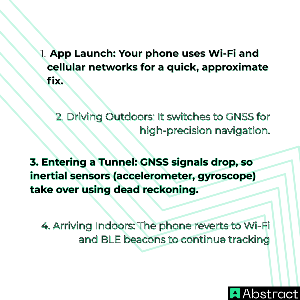
This dynamic approach ensures smooth performance, even when one data source fails. It's the same principle behind autonomous vehicles, AR navigation, and smart city infrastructure.
The Future of Geolocation: Accuracy, Speed, and Ethics
The geolocation landscape is evolving rapidly—becoming more precise, integrated, and intelligent.
🌐 Emerging Trends
- 5G Positioning: Ultra-dense 5G networks enable centimeter-level accuracy without satellites.
- Next-Gen GNSS (L5 Signals): New signals like GPS L5 reduce multipath interference for better urban accuracy.
- Edge AI and Sensor Fusion: Real-time data processing at the device level improves responsiveness and privacy.
These innovations are transforming sectors like logistics, AR gaming, and connected healthcare.
🔒 Privacy and Responsibility
With great accuracy comes great responsibility. Developers must handle location data ethically—respecting user privacy, consent, and legal frameworks like GDPR and CCPA.
AbstractAPI's location tools, including the IP Geolocation API and Timezone API, prioritize data minimization and secure requests, helping you build location-aware apps without compromising compliance.
🧩 Final Thoughts
So, Geolocation vs GPS isn't really a contest—it's a misconception.
GPS is just one method within the broader geolocation ecosystem, alongside IP lookups, Wi-Fi mapping, and proximity-based sensing.
The real power lies in combining these technologies—using each where it performs best—to create smarter, context-aware systems.
By understanding this ecosystem and leveraging developer tools like AbstractAPI's Geolocation APIs, you can build applications that are accurate, efficient, and privacy-conscious—ready for the next generation of location intelligence.
Frequently Asked Questions
What is the difference between geolocation and GPS?
Geolocation is the broader process of identifying a device's position using any available data source: GPS, Wi-Fi, cell towers, or IP addresses. GPS is just one specific technology within that ecosystem, using signals from satellites orbiting about 20,000 km above Earth. The two terms are often used interchangeably, but GPS is only one method of achieving geolocation.
When should I use GPS vs. IP geolocation in my app?
Use GPS when you need precise, real-time coordinates: such as navigation, asset tracking, or augmented reality. Use IP geolocation for server-side tasks where device access is unavailable or unnecessary, such as content localization, fraud detection, or matching a user's region without requiring location permissions. IP geolocation is accurate to the city or regional level (10-50 km), while GPS achieves 5-10 meter accuracy outdoors.
Does GPS work indoors?
GPS performs poorly indoors because satellite signals are blocked or weakened by roofs and walls. For indoor positioning, alternatives like Wi-Fi positioning (10-50 meter accuracy), Bluetooth Low Energy beacons, or Ultra-Wideband (UWB) are better choices (with UWB reaching sub-meter accuracy). A sensor fusion approach that switches between methods depending on environment gives the most reliable coverage.
What is sensor fusion and why does it matter for location apps?
Sensor fusion is the technique of combining data from multiple location sources: GPS, Wi-Fi, cell towers, accelerometers, and gyroscopes, to produce continuous, accurate positioning even when one source fails. Modern smartphones do this automatically to smooth out GPS dropouts in urban canyons or tunnels. When building location-aware apps, designing for sensor fusion means your app degrades gracefully instead of losing position entirely.
How accurate is IP geolocation compared to GPS?
GPS achieves 5-10 meter accuracy in clear outdoor conditions. IP geolocation is far less precise, typically resolving to the city or regional level, with an error range of roughly 10-50 km. Cellular triangulation falls in between at 100-1,000 meters. For use cases where rough location is sufficient (regional content, currency display, fraud checks), IP geolocation's negligible power cost and no permission requirement make it the practical choice.
What causes GPS inaccuracy in urban areas?
The main culprit is the "urban canyon" effect: tall buildings reflect satellite signals, causing multipath errors where the receiver picks up the same signal via multiple routes. Atmospheric interference from the ionosphere and troposphere also delays signals, and poor satellite geometry (measured as Dilution of Precision, or DOP) compounds the problem when fewer satellites are visible. Supplementing GPS with Wi-Fi positioning or cellular data in dense urban environments significantly improves reliability.
